
The Peaks of the Balkans hiking trail leads through the mountainous region on the border between Montenegro, Albania and Kosovo. I am the 192 kilometres hiked in 8 days in the year 2024. I loved it, hated it, made a number of small mistakes, broke a walking stick and an air mattress and covered 40 kilometres in one day. Read my Experiences and my story about solo hiking on the Peaks of the Balkans through Albania, Kosovo and Montenegro.

This is an overview of my experiences hiking solo on the Peaks of the Balkans. Please see the separate posts on the Planning my Peaks of the Balkans trip and my packing list for Peaks of the Balkans.
A brief introduction to the Peaks of the Balkans
With a length of 192 kilometres, the Peaks of the Balkans hiking trail connects three nations, Albania, Kosovo and Montenegro, and crosses some of the continent's least explored landscapes.

Distance: 192 km
Duration: 10 days. Very fit hikers carrying only light packs can complete the route in six or seven days. For those who prefer a more leisurely schedule, including a rest day and a few detours, the hike can take up to 12 or 13 days.
Level of difficultyMedium
Total elevation gain / loss: 12.020 m
The Peaks of the Balkans is no longer the well-kept secret it was when I first heard about it five years ago. Apart from the Theth to Valbona section (which attracted hundreds of people as the most popular day hike in Albania), I rarely saw more than half a dozen people a day on the trail itself, but the guesthouses I stayed in were usually full, and there are usually at least 2-3 people at the end of each section. Guest houses. It is sometimes possible to stay in the guest houses without a reservation, but I wouldn't rely on it.
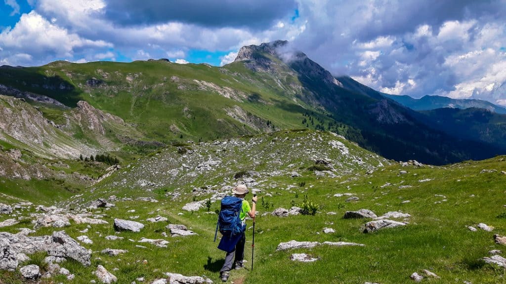
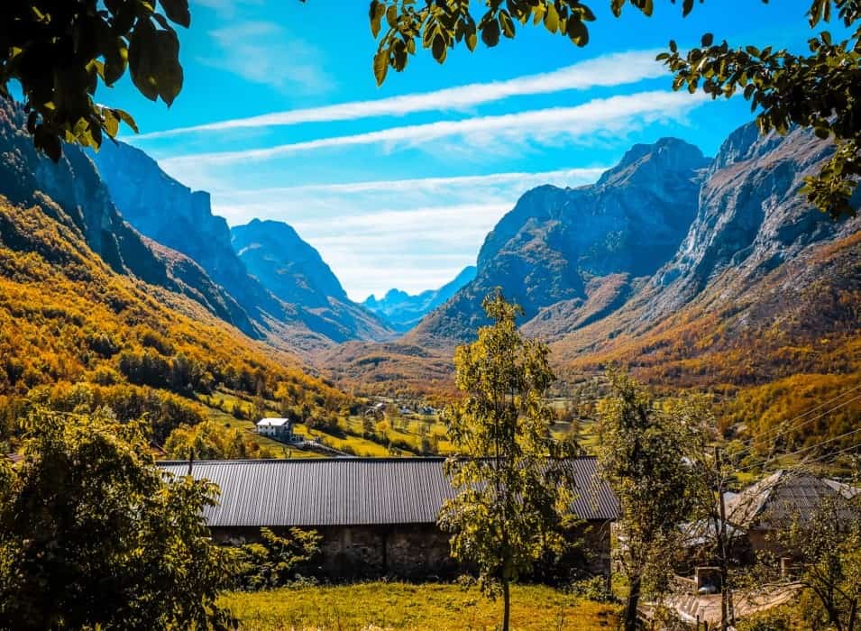
Hiking through the green valleys and wildflower meadows, you can sense the utter remoteness of this fascinating region, with the grey Albanian Alps, known locally as Prokletije, towering above. Unlike the better-known European Alpine regions, there are no hotels or ski lifts in this region, which adds to the feeling of remoteness and the sense of immersion in a hidden world that has escaped the attention of the outside world.
The "Peaks of the Balkans" adventure allows hikers to explore these breathtaking landscapes while immersing themselves in the cultural diversity of the region. The trail not only presents a physical challenge with its rugged terrain, but also offers you the opportunity to interact with the local communities and experience their hospitality. This transnational trail not only showcases the natural beauty of the Balkans, but also serves as a symbol of unity and co-operation, uniting nations through a shared love of their extraordinary landscapes and a desire to share them with the world.
Day 1: Journey about Tirana, Koman Lake and Fierze to Valbona
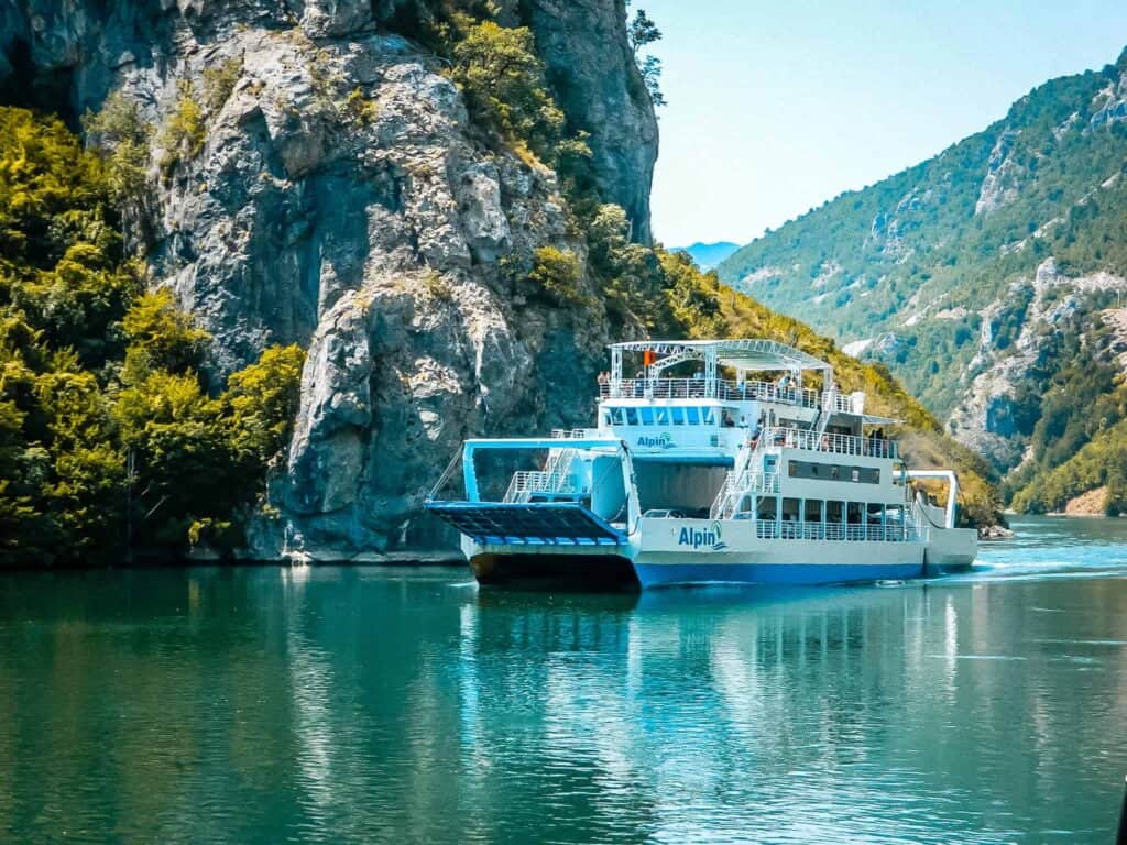
I stood there staring open-mouthed. I had seen some pictures before, but nothing could prepare me for what I was about to see. I was standing on an old, rusty ferry that took me and many other tourists across Lake Komani from Koman to Fierze, which was breathtakingly beautiful.
I had decided to take a diversion to get to the trail from my home in Germany. Most people started in Theth or Plav, but since I wanted to fly with my favourite airline and had seen pictures of Lake Komani, I decided to fly to Tirana, take a 3-hour bus ride from Tirana to Koman, take a 2.5-hour ferry ride from Koman to Fierze and finally take a 1-hour bus ride from Fierze to Valbon.
My experience: The journey was longer than necessary, my flight was delayed, the taxi to my hotel arrived 45 minutes late and I had only slept for two hours after waking up at 4.30am. But it was worth it.
The ferry travelled slowly through a fjord-like landscape that reminded me of both Thailand and the beautiful Nordic fjords. We were surrounded by majestic nature, with impressive cliffs and beautiful forests. From time to time, small speedboats overtook our ferry, like the ones you see on rivers in Asia. And here and there, a house or a small settlement on the mountainsides or at the water's edge was the only evidence that people actually lived there.
The ferry proved to be the lifeline of the region. Locals regularly boarded and disembarked with suitcases, food or building materials. We witnessed family reunions, young adults leaving their parents' homes to move to bigger cities, villages being restocked and tourists disembarking in kayaks for a day of water fun. It was a truly magical place.
After two flights, two buses and a ferry ride, I finally arrived in Valbonë. After a quick lunch, I was ready for my own adventure: a week on the Peaks of the Balkans Trail.
Stage 1: Valbonë - Prosllopit Pass (8.2 km, 1000 vertical metres, 3 hours)
So much for all the positive vibes. After all these years, I've gained quite a bit of hiking experience, but today I've simply made all the rookie mistakes you can make.
It's not even 15 minutes since I started my "Peaks of the Balkans" adventure and I'm already seriously doubting what I've let myself in for. I can't even find the start of the trail at first because the directions in the booklet are confusing (it points out certain inns - many have similar names - and a sign - there are two similar ones). Well done, Polle.
When I think I've found the start of the path, I try to jump over a small stream, but I've completely misjudged the distance and my weight with the rucksack and end up with both feet in the stream. Great, just great. Wet feet for the rest of the afternoon.
I finally start the steep climb from Valbone to the Prosllopit Pass, but I lack cadence and speed. Step by step, I try to get into the rhythm of the trail. I keep looking at my watch to check my speed and am frustrated by everything. I could easily blame it on the two hours of sleep last night, but that would be too easy.
After a few hours, I discover the perfect flat area to camp. Sheltered from the wind, flat, with a beautiful view. Only when I arrive do I realise that it was also the perfect toilet for the cattle grazing nearby, as the ground is littered with cow dung. Sure. Why not? When I find a new spot and pitch my tent, I realise that my air mattress - which I had checked before I left - has a hole in it and won't inflate. Crazy.
Finally, for some reason, my Garmin InReach has reset itself to the previous settings and I can't get it to work. As a precaution, I check in with my family via satellite phone every morning when I break camp and check out when I pitch my tent, just to let them know I'm safe and where I am (the phone automatically sends my exact GPS coordinates). Without mobile phone reception, I can't check out via WhatsApp and I can't reset my InReach. Fantastic.
Tip: It's really worth going on short hikes in your home country beforehand to prepare yourself for the trail. In my experience, you are quite rusty and the hiking trail is quite challenging in places. Stamina is necessary.
Day 2: A day full of premieres
Stage 2: Prosllopit Pass to Doberdol (29.6 km, 1400 vertical metres, 7.5 hours)
New day, new opportunities. After a good night's sleep, I pack up my tent and equipment and set off for Doberdol. It's my first real day on the trail and I'm looking forward to soaking it all up. I've missed it so much.
And I'm not disappointed. The path looks great and the view is fantastic. It's a day of many firsts. I come across my first of several sheep jams along the way, so I have to wait for the sheep, the shepherds and especially the dogs to pass (make sure you never get between the sheep and the dogs as this usually doesn't end well). I come across the first makeshift local café selling cold Coca Cola (I never actually drink Coke, but on hot days on the trail it's simply divine).
I curse myself for the first time on this trip, muttering aloud to myself that everything is going so smoothly, just moments before I slip and fall, breaking the plug of my USB charger in the process. And somewhere on the descent to Cerem, I bump into my first group on the trail, about 20 immaculately dressed Italians making their way to the Maja Kolata Pass.

As I pass most of them, their guide asks me what the weather is like on Maja Kolata. He obviously doesn't know. I don't know either, as I haven't done the extra loop to Maja Kolata. But I do know that it's windy that day, that parts of the path towards Maja Kolata are exposed (rocky, open to the wind, with a big drop), that several lives are claimed on this route every year and that most of his group are dressed for yoga or a cycling class rather than a difficult hike up a dangerous peak.
When I arrive in Cerem, I decide to try the local cuisine for the first time at the famous Kujtim Goçi Guesthouse. It is simply perfect. The potato and carrot soup, the tomato, cucumber and onion salad, the local bread and some rice with vegetables and meat are so simple and yet so perfect. The hosts are extremely friendly and welcoming, and it's a more than welcome pick-me-up for the rest of the day.

Another first follows in the afternoon. I follow a 4WD road (four-wheel drive, one of many) up the mountain and at some point routinely check my GPS to see if I'm still on the right track. And it turns out I'm a kilometre off and have missed a path up the mountain. I was 100 % sure that I was following the 4WD road straight ahead as described in the hiking guide. When I return to this point, I realise what has happened.
There is a junction where there is actually a side road straight ahead, but over the years the junction has become the main route, so I follow the main route through the junction instead of the side road. It is the first of many times that the signposting is not 100 % clear and the description in the booklet is overtaken by reality.
By the time I arrived in Doberdol that evening at around 19:00, I was tired and didn't have the energy to walk any further, climb out of the valley and find somewhere else to stay. So I decided to camp at the Guest House to experience another first. A group of Dutch people were also camping here. And another first on the trail: one of the group has to be evacuated due to illness, and I end the night with a badly pitched tent and only one trekking pole. The perfect end to the first day.
Day 3: Familiarising yourself with the hiking trail
Stage 3: Doberdol to Lake Pusi-i-Magareve, just after Milishevc (23.6 km, 1400 metres altitude, 6.5 hours)
I'm glad that the second day brings fewer firsts and unwanted surprises. I get used to the hiking trail and enjoy the surroundings.
The most important realisation of the day is the water situation. I had been warned about the water in Doberdol (the river there is polluted by toilets in the higher areas that literally dump their shit into the river, so to be avoided at all costs), but despite being very careful, I can't leave Doberdol without stomach problems - the same goes for most of the Dutch group. It's also difficult to predict the water situation. In general, there are many more water points, springs, streams etc. on the trail than described in the brochures. However, they are usually not in the places where you would expect to find them.
My experience: Springs and streams that should be there according to the information in my brochure or on my GPS device are not there, while in other places you pass three streams with perfect water within a few minutes.
Tip: Water is hardly a problem, it's fine to follow the literal course of water, but plan on your water points not being in the places you expect them to be.
I keep up a good pace, have a good lunch in Milishevc and hike to Lake Pusi i Magareve to camp there. I'm the only one there and go to bed early to make up for the bad night's sleep I had last night due to my walking stick breaking down.
Day 4: Cold awakening
Stage 4: Lake Pusi i Magareve to Drelej (23.1 km, 1000 vertical metres, 6 hours)
I wake up after a hard night. The temperature in the valley where the lake is located has dropped below zero degrees and the cold has kept me awake all night. I finally sleep in my sleeping bag with all my clothes on: two T-shirts, my fleece jacket, my rain jacket and my long trousers, just to keep me warm. My rucksack, which was in my tent, is covered in ice.
The outside of my tent is completely covered in ice and my hands go numb as I try to fold it up again. I pack up as quickly as possible and leave the valley to warm up in the sunlight. It takes 15 to 20 minutes before I have full feeling in my hands and feel comfortable again.
After warming up, I'm curious to see how my knees will cope with the long descent from Pusi i Magareve to Rugova Camp. A descent of over 1000 metres over a distance of 7 kilometres is a real challenge, especially after such a long period of inactivity. Surprisingly, my knees and legs hold up very well and I can keep up a decent pace on the descent, which makes for a very smooth start to the day.
I have an important decision to make. The route from Drelej to the next village, the Te Liqui restaurant in Kosovo, runs for 13 kilometres along a busy road. So I either have to push my bike to the Te Liqui restaurant or stay in Drelej. After covering over 7 kilometres on the tarmac road between Rugova Camp and Reke e Allages, I decide I've had enough of tarmac and ask the owner of Shquiponja Guesthouse if he can take me to Te Liqui restaurant to skip another long stretch and make the next day bearable.
I use the rest of the day to relax in the very inviting and comfortable Shquiponja Guesthouse, get some rest, eat good food and relax. Eat and prepare myself for the busy day ahead.
Day 5: The marathon day
Stage 5: Restaurant Te Liqui to Plav and beyond (42.6 km, 1900 metres altitude, 10 hours)
Although I have skipped the section from Drelej to the Te Liqueni restaurant, today promises to be a very long and strenuous day. The friendly owner of the Shquiponja Guesthouse, Ilir, drops me off at the Te Liqueni restaurant at around 8.30 a.m. and I set off on the long journey to Plav, a total of 35 to 36 kilometres.
This should be doable, as the biggest challenge lay in the first 7 kilometres of the trail, where it climbed slightly over 800 metres towards Qafa e Jelenkut. After that, the path was mostly flat or sloping.
I had been struggling with the steep climbs over the past few days and made some adjustments. I set my Garmin watch to show my heart rate instead of speed, distance and hours elapsed. I had found that the latter distracted and disappointed me and tempted me to take more short breaks than I wanted/needed. I also adjusted my pace. Instead of my normal pace, I took smaller, slower steps, but didn't stop.
I took my lunch break at Bobino Polje. Although the lodge was still under construction, it was very welcoming. I played a game of Uno (which is apparently incredibly popular in the region) with the owners' son and had a great lunch. Checking my mobile phone for messages, I saw a friendly message from the owners of the guesthouse I was staying at in Plav. At least that's what I thought. I remembered that I had chosen the guesthouse because it was close to the hiking trail. I had booked the Guesthouse Grandfather's Place, which is indeed close to the trail.
But later, when I was preparing for the trail, I mistook it for another guesthouse, Grandpa's House, which is also in Plav and right on the trail. But while Grandpa's House is in Plav itself, Grandfather's Place is in Budovice, another 6-7 kilometres from Plav. This means that I don't have another 20 kilometres ahead of me that day, but another 27. This means that I have to hike not just 20, but 27 kilometres that day. So I quickly pack my things, fill up with water and pick up the pace to make it to Budovice in time.
I only allow myself a short break at the breathtaking Lake Hridsko Jezero. It's a great place for swimming (sorry, no time) or camping (definitely no time for that). I enjoy the breathtaking view and sit down next to a large group of Croats who are enjoying their time in the sun. After 15 minutes, I break camp and hurry back to Plav and Budovice.
When I finally arrive at the guesthouse, it's already dark. To our surprise, the same Croatians who were at the lake in the afternoon are now having dinner and a few drinks to celebrate one of their birthdays in the evening. They invite me for a shot of the local rakije and before we know it, it's 3am.
Day 6: Recovery on a merciless hiking trail
Stage 6: Beyond Plav to Vusanje (16.8 km, 1000 metres in altitude, 4.5 hours)
After a long day and an even longer night, I treat myself to a little sleep. The Grandfather's Place guesthouse is the perfect place for this. It's by far the best accommodation I've had on the trail. The Feratović family are extremely friendly and hospitable and do everything they can to make their guests happy.
The sons are great hosts, the mum is responsible for the great home-cooked food and the dad makes sure the property is well looked after. After enjoying a delicious breakfast and even being allowed to wash my clothes, I say goodbye to my new friends at around 11.00 a.m. to set off for Vusanje.
The Feratović family shows me a path directly from their guesthouse back to the trail (to a katun on the trail that bears their name), which turns out to be less travelled than the Peaks of the Balkans trail. It requires some scrambling over fallen trees and detours to finally reach the saddle just before the Bajrak summit.
This point is notorious as it lies just before the steepest ascent of the trail. I take a short break before the climb. It turns out that this is a favourite moment and a popular route on this day. I meet three Germans and hear that I've just missed another group of 40 Dutchies.
One of the ladies in the group is lying flat on the trail with a guide and her husband due to calf and stomach cramps. I feel really sorry for her; it's her first day on the trail. I offer to help, but the guide has everything under control and she will soon be evacuated. This is further proof that while the trail may seem comfortable and Instagram-famous, it's still nature and the trail is often unforgiving.
I continue on my way and gradually catch up with the group of 40 people. This gives me a good insight into the type of people who join these groups. From people who want to lose weight and see this as a suitable way to do so, to a local tour guide who is sometimes clearly annoyed by the group's ignorance of the local culture and history, from older couples to groups of friends, from father-son pairs to hobby hikers.
Later, I take a break in one of the makeshift cafes along the way to rest and chat to two Australians who are scouting the trail to offer tours for Australians, and one of the guides from the Dutch group who offers to come along as a guide next year. I politely decline; it feels like there are already too many guides and groups on the trail.
I take it easy and finish the last stage in the direction of Vusanje, where I have dinner and go to bed early to recover from the marathon of the last day.
Day 7: Change of plan to avoid bad weather
Stage 7: Vusanje - Theth (23 km, 1100 metres in altitude, 8 hours)
Dinner at the guesthouse was disappointing, so I decided to skip breakfast and rely on my own supply of bars and other food. I set off early to give myself some flexibility that day. I had heard that the weather was going to be bad tomorrow, so a little extra time gave me some flexibility just in case.
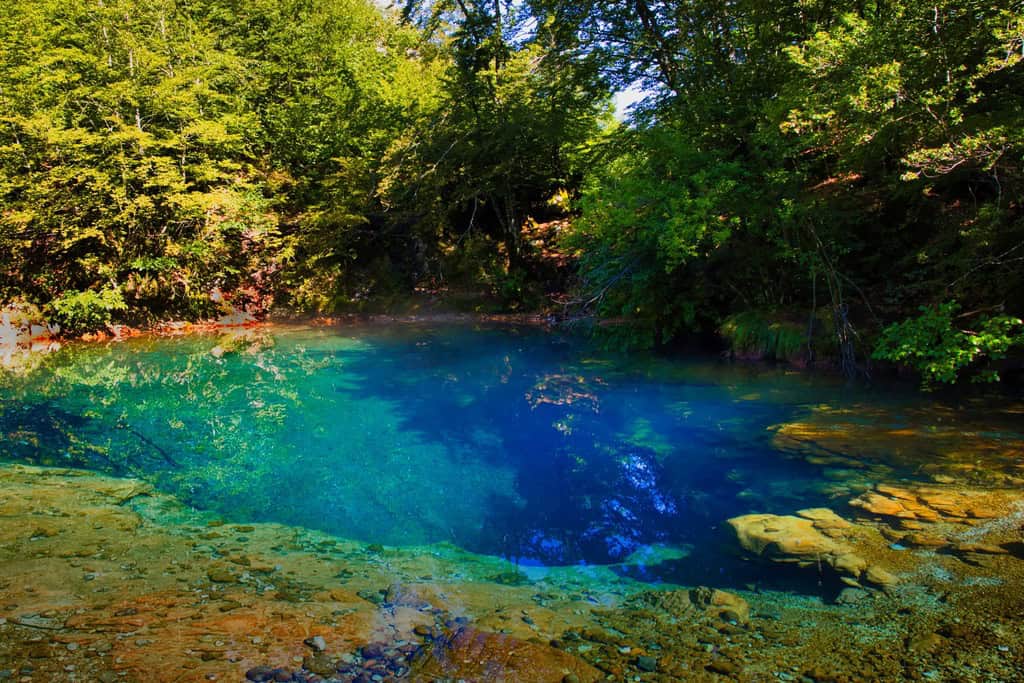
The route through the Prokletije National Park towards Theth was beautiful. I made a short stop at the Blue eye of Vusanjea deep pond from which a breathtaking river flows. I enjoyed the view of the impressive Maja e Harapit before descending towards Theth.
Water was scarce on the way up, so I gave the Italian family everything I had, knowing that I would soon be in Theth and resupplying myself with water. Theth was a lively village full of tourists taking day trips, going swimming, visiting the famous church and exploring the rest of the old village.
While I was having lunch in Theth, I looked at the weather again and saw that the forecasts for bad weather tomorrow seemed to be coming true. I had planned to camp behind the Valbona Pass and walk the last 10 kilometres on my last morning to catch the bus back to Tirana in the morning. But that seemed too unsafe, so I decided to spend the night in Theth.
Day 8: The spectacular Valbona Pass
Stage 8: Theth - Valbone (15 km, 1200 vertical metres, 7 hours)
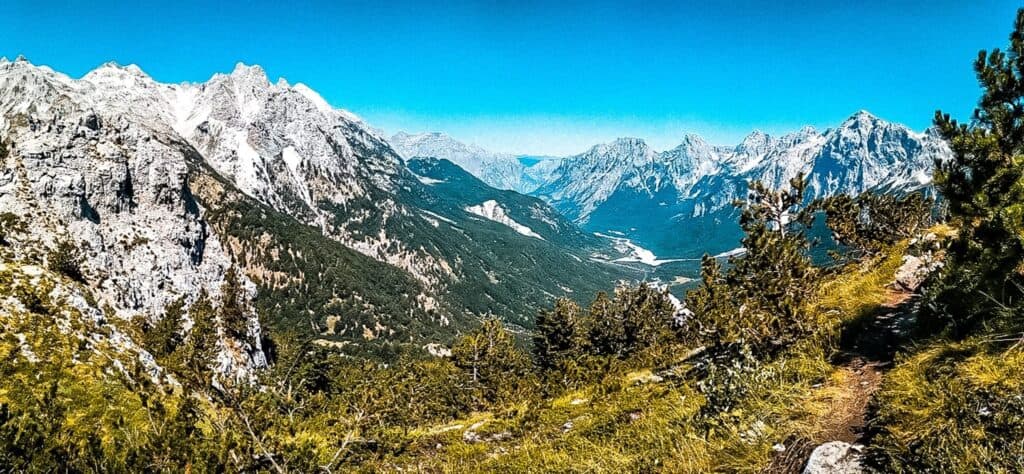
On this stage, I hike through the most touristic and popular section of the Albanian Alps. In the last few days, many people have told me that this route is very crowded. The hiking trail from Theth to Valbona is one of the most beautiful hikes in this breathtaking region.
The hike from Theth to Valbona is around 15 kilometres long and takes around 7 hours according to the signs. The path winds its way through bumpy gorges, steep mountain paths and green valleys. Along the way, you will be rewarded with panoramic views of snow-capped peaks and lush alpine meadows.
I stocked up on water for the hot and steep ascent to the Valbona Pass. The climb was interesting as every few hundred metres I came across a new group of hikers who, after enjoying the view from the Valbona Pass, descended back to Theth - exactly the opposite of my intentions.
I met an interesting group of people on the way. This is probably best illustrated by the statement of a lady who runs one of the cafés on the mountain. She says that she is asked several times a day by tourists climbing up to the Valbona Pass whether they can pay by card in her café. This drives her crazy and frustrates her immensely because her café is literally in the middle of nowhere and cash is the only way to pay (as it is in the entire region).
Some groups mistake me for a guide (as I heard at one point because people thought I was fast and both my Garmin InReach as well as wearing my GPS on my chest) and ask me how long it will take them to reach Theth (which is impossible to estimate - it's hard to estimate speed and distance for a group of people you don't know). I'm pretty sure some of them didn't make it before dark, though.
From here you can see the mountain "Maja Jezercë", the highest peak of the cursed mountains that stretch across Kosovo and Montenegro. The pass also offers views of the Theth and Valbona valleys.
I reached the pass at around 11:00 and set off to make it to Valbon on time. I increased my pace even further and finally arrived in Valbon at 16:00. What a day. What a week.
The next morning I am very glad that I didn't exert myself so much the day before. The weather had completely changed. Lots of wind and heavy rain showers would have made it impossible for me to get to Valbone on time and probably spoilt my night's sleep.
One last thought - stairs on the Peaks of Balkans
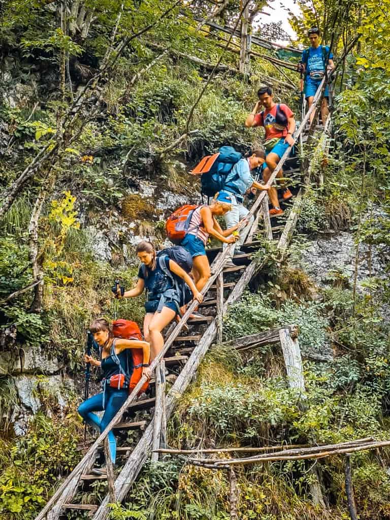
Wooden stairs. Wooden stairs. It's the last day, and they summarise what probably bothered me about the Peaks of the Balkans Trail. It's becoming too popular, too busy and too commercialised for my personal taste.
Don't get me wrong, the Peaks of the Balkans is a fantastic hiking trail. The views are breathtaking, the trail (apart from some longer stretches of tarmac) is fun, different and beautiful. The people are fantastic; in all my years on the trail I've never seen so many friendly, proud and genuinely interested locals. I've enjoyed every single day on the trail and would definitely recommend you try it before it gets spoilt.
My experience: The "temporary café" from the 2016 booklet is now a proper café with a kitchen. The "scattered summer camps" from the same book are now entire villages. One of the cafés along the way charged €3 for a can of Coca Cola in a bucket of water (prices varied between €1.50 and €2.50). One of the guesthouse owners along the trail has changed the markings to lead the trail around his house. And there are stairs. No path needs stairs. Full stop.
And with accessibility, awareness and commercialisation comes danger. In the eight days I spent on the trail, I saw one person transported off the mountain due to cramps, one person due to illness (and many others suffering from forms of gastrointestinal illness in the Doberdol area), a large family who hadn't planned well and got stuck on the mountain in the dark and had to be brought out by a café owner on the mountain, and several hikers who weren't up to the task of hiking one or more sections of the trail.
My experiences: What I learnt in a week on the Peaks of the Balkans Trail
So what are my most important findings after several days in the region?
- A popular hiking trail. The hiking trail is becoming increasingly popular. I met two groups of 40 Dutch hikers and I can't count how many others I met on my last day on the trail (the routes leading to Plav and Theth are notoriously busy). These crowded hiking trails are not for everyone. In future, I will probably opt for less popular hiking trails or for the "off-season".
- A great hiking trail, even better people. The hiking trail is breathtaking and the locals are even more impressive. They are extremely friendly, welcoming and genuinely interested in visitors.
- Choose your entry point wisely. In hindsight, travelling to and starting in Valbona was not a good idea. Most of the hikers I met travelled via Shkoder to start the Peaks of the Balkans in Theth. Next time I would start there.
- Be well prepared. Although the trail is well signposted overall (more on this later) and should be doable for many people, there are many inclines and declines. It's still nature, and the weather can change quickly (as I learnt in the Nordic countries). I should have checked my equipment three times (my walking stick and air mattress let me down). Overall, better training, better planning of days and routes and adequate equipment are essential.
- Pay attention to possible changes in the route guidance. The region is developing so quickly (e.g. deforestation, new roads, new buildings, changes to markings by guesthouse owners, hiking trails not matching the description in your book or GPS file) that you should be constantly on the lookout for changes.
- Take a GPS with you. Although the trail is well signposted, you have to check the GPS several times a day for changes. It is essential to have a good offline hiking map on your mobile phone or a special GPS device such as a Garmin GPSMAP to have with you.