
Peaks of the Balkans stage 6: Rekë e Allagës - Guri i Kuq
Stage 6: Hike Reka e Allagёs - Drelaj - Guri i Kuq
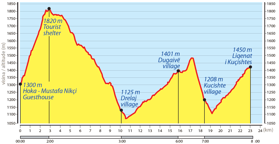
Route length: 23.26 kilometres.
Minimum altitude: 1,072 metres, maximum altitude: 1,820 metres.
Total altitude uphill: 1,257 metres, downhill: 1,139 metres.
Difficulty level: medium.
Time: 8-9 hours.
Markings: red/white/red
The transfer hike to Kuçishtё is long and interesting and offers the
Possibility to visit a few other villages along the way. Although this is a long day hike, the level of difficulty is low as the majority of the hike is on dirt and gravel paths. There is also the option of cancelling the hike and returning to the village.
continue with the vehicle to the last point.
For a less demanding hike, the trail can be divided into two parts. The best
An option for an overnight stay is the village of Drelaj (WP 9e), where you can
can stay with the family of Osman Shala, tel. +37744586740. The route
from Reka e Allagёs to Drelaj is 10.1 kilometres and from here to
Kuçishtё (Guri i Kuq) or Leqinat i Kuçishtёs 12.9 kilometres.
Peaks of the Balkans stage 6 - Map & elevation profile
The hike begins with a climb to the north-west through the meadow behind Mustafa
Hakaj's guest house (WP 15d). As soon as we approach the pine trees, we turn right
(eastwards) onto a mule track. The path is lined by a fence on our right and a few
A few metres further on, we turn left at the crossroads (SS 1e). After a few hundred
metres in a north-easterly direction we reach a meadow with a beautiful view
Reka e Allagёs and the surrounding mountains.
At SS 2e, we cross the field path and follow the ascent to the north-west through the
Forest. At the crossroads we turn left (SS 3e) and then follow the road northwards until we reach
leave the forest and reach a beautiful meadow and a tourist accommodation (WP 5e). This is a
inviting place to relax.
From here, we follow a dirt road westwards to the village of Pepaj. On the way to Pepaj
there are two water sources along the road. At the junction of SS 6e and 7e
turn left and the descent to the village of Pepaj can be seen from both positions. After
After approx. 1 kilometre we see the cemetery (SS 8e) and turn left.
A few metres further on, turn right at the crossroads. The descent is very gentle along a gravel road,
which is no longer travelled by cars; car traffic has been shifted to a newer
road. If we follow this road for a few kilometres, we reach the village of Drelaj (SS 9e)
and from here turn right at the crossroads. We continue south-westwards through the
village along a road lined with fences. This road leads us to the end of the village, a bridge
(SS10). We cross the bridge and follow a gravel road that runs alongside the
river northwards into a beautiful gorge.
If you want to end this hike, you can turn left after crossing the bridge and walking for about 30 minutes
. 1 kilometre further on you will come to the main road. Here you can take a
Hire a taxi to Kuçishtё (WP 20e).
Keep left at the crossroads at SS 11e and follow the ascending gravel road to the north-west.
When we arrive in Dugaivё (SS 14e), we don't take any of the dirt roads;
Instead, we follow the path south-westwards along a meadow, then southwards to the forest. We follow the path
to the south at SS 15e and about 200 metres further on we start the descent on a
Mule track through the forest that leads us to the village of Kuçishtё (WP 16e). In the
village, we take the dirt road and continue south-west until we reach
meet the tarmac road at the bridge (SS 17e).
In this village, it is worth visiting the Catholic church, which is located on a place called "Church Hill"
(ask the locals for a guide or directions). The ruins of this church
represent one of the most valuable monuments of medieval Rugova.
To get to the Guri i Kuq Hotel (the point closest to the starting point of the next hike),
follow the road southwards for approx. 3.8 kilometres, then turn left at the crossroads of SS 18e
and 19e turn left.