This is a relatively long hike that crosses the border between Montenegro and Albania
. The path leads along the most rugged part of the Prokletje/Bjeshkёt mountains
e Namuna/Alpet Shqipёtare. Almost the entire hike is
surrounded by steep mountains with breathtaking views. This route gives us a glimpse into
the region's past, when it was a forbidden zone during the communist era. At the border crossing there is still a
Border military posts, a bunker and the pyramid sign
of the border crossing. The transfer hike ends in the beautiful village of Theth with its
traditional tower houses surrounded by steep mountains.
If you want to split this hike into two parts (two days), the best place to spend the night is the meadow at Sheh i Bardh (WP 6i), where you can pitch your tent.
can build up .
In summer there may also be shepherds at the former
Border police buildings where you can buy fresh food. This place is located
almost in the middle of the path.
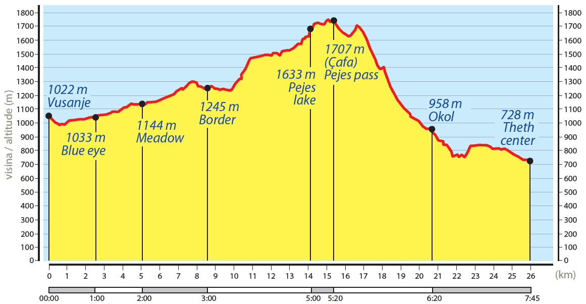
The hike begins in Vusanje (SS 4h) and runs south-west along a dirt road. After
After about 300 metres we find a beautiful waterfall that springs from the river Grlja (WP
1i). Our hike continues along the field path and after approx. 1.4 kilometres we turn right onto the
turn right and continue for about 50 metres along a narrow footpath until we reach
to another attraction in the area - the "Blue Eye". The blue eye is a small lake, the richness of which
groundwater sources give it the bluish colour of its water (WP 2i).
From the blue eye, turn back to the dirt track and follow it south-westwards. After
After approx. 2 kilometres we reach a beautiful meadow (SS 3i). Travellers can
can also reach this point with all-wheel drive.
Our route leads gently south-westwards along an easy path lined with steep mountains
. After following the valley for about two kilometres to the southwest, we reach a lake (Lićeni Gšfars), which in the summer
may have dried out .
We follow the path to the south-west and after about 500 metres
we reach the Albanian border, where a pyramid (WP 4i) from communist times
reminds you that you have entered a border area. On the pyramid, the Albanian motif and the
letters "RPSSH". RPSSH is an abbreviation for "Sozialistische
People's Republic of Albania" (Republika Popullore Socialiste e Shqipёrisё).
From the border, the route continues uphill to the south-west, initially through an oak forest,
then through a pine forest, after approx. 1.4 kilometres we reach a very beautiful
beautiful meadow (Fusha e Ruinicёs). This is an inviting place to relax. At Fusha e
Ruinicёs there is a water source near the shepherds' summer huts (WP 5i).
The route continues on a visible path to the south over flat terrain that gently
ascends through the valley. After approx. 1.5 kilometres we reach a
Bunker and then a water source (SS 6i). 100 metres further on. The
abandoned building near the water source was once a military building
to protect the border. There is also a beautiful meadow here (She i Bardhё), a good
Option to camp if you are not planning to drive directly to Theth.
From She i Bardhё, the route follows the gentle ascent southwards along a visible path.
We begin to descend several metres as we approach Lake Pejёs (Albanian:
Liqeni i Pejёs or Liqeni i Peshkeqes) at WP 7i. From the lake we start an ascent
south and reach the Pejёs Pass (Qafa e Pejёs) after approx. 30 minutes. 400 metres. Qafa e
Pejёs (WP 8i) offers a breathtaking view of the Theth Valley.
Our descent from the pass zigzags southwards on a very steep but well-maintained track.
and safe route. This leads us into the Theth valley. When the descent becomes gentler,
the visible path leads through a wooded area with pine trees. After approx. 1.3 kilometres
Through the forest we reach a water source (WP 9i). The spring itself is located
approx. 700 metres before the village of Okol in the Theth Valley. From Okol, we follow a dirt road
Road southeast over flat terrain on the edge of the Thethi River and reach the village of Theth
(SS 10i) about 3.8 kilometres later.
There are village inns in both Okol and Theth. Theth is also a good
Option to spend a day or two visiting the surrounding sights (e.g.
blue eye, waterfall, blood tower, ethnographic museum, etc.).