A transfer hike to Babino Polje, Montenegro, is scheduled for this day. This is a relatively long hike that crosses the border between Kosovo and Montenegro.
The route leads through beautiful mountain regions with many water springs, glacial lakes and
Mountain passes with breathtaking viewpoints.
From Guri i Kuq to Babino Polje there are no accommodation facilities/villages along the way, but you can camp. We recommend camping at the Lugu i Shkodres Pass (WP 4f ) or between the Jelenka Pass and Ravno Brdo Pass - near the small lake (WP 7f ).
If you decide to split this hike into two sections, the first day would be mainly uphill and the second day mainly downhill. Taking into account the division of the trail WP 7f, the length of the first day is 7.4 kilometres and the second day is 8.4 kilometres. Please note that camping outside organised campsites is not permitted in Montenegro.
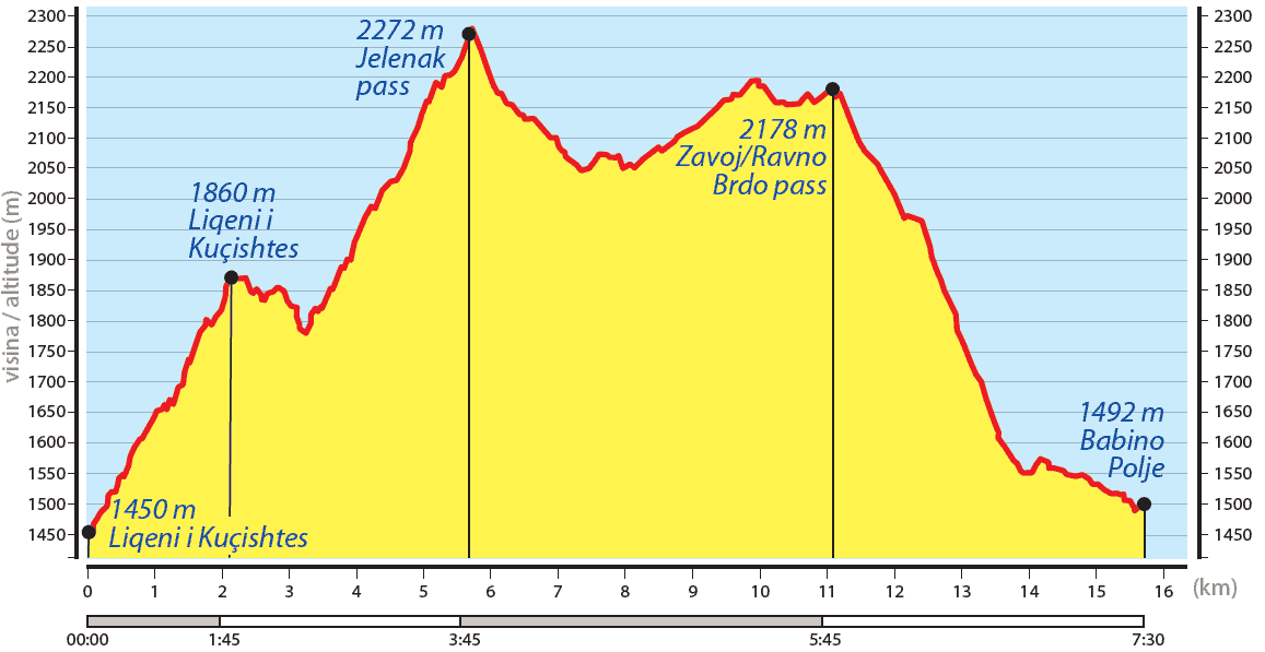
From the Guri i Kuq complex (WP 20e), the trail climbs gently southwards along a dirt road, which later turns into a hiking trail marked with red circles. After about 2.2 kilometres uphill, we reach a beautiful glacial lake. The locals call it Liqeni i Kuçishtёs (WP 1f ). Our route leads about 500 metres to the north-west, then to the south-west. A few metres further on, we reach a water source (WP 2f ) and a glacial lake called Liqeni i Drelajve (WP 3f ).
Up to this point, the path is clearly visible, but after passing the second glacial lake, the path becomes less conspicuous and requires good judgement.
Skills. A GPS device or a local guide is recommended for this part of the hike.
From Liqeni i Drelajve, the trail leads uphill in a south-westerly direction to the Lugu i Shkodrёs Pass (WP 4f ). The pass is called Lugu i Shkodrёs (Shkodra Pass) because it used to be called
because it used to be the pass of an old road that connected this area with the town of Shkodra in Albania.
There is a water source at the Lugu i Shkodrёs Pass (SS 5f ). Our hiking trail leads in a southerly direction about 400 metres uphill until we reach the Jelenka Pass (WP 6f ). From here we can see the Babino Polje valley. We start the hike in a south-easterly direction downhill and after about 1.5 kilometres we see a small artificial lake (WP 7f ). The locals use it as a water reservoir for donkeys, horses etc. From here, the path runs south-westwards through almost flat terrain until you reach the Ravno Brdo pass (SS 8f ). From the Ravno Brdo pass we have a very clear and beautiful view of the village of Babino Polje.
The hiking trail is not always visible due to the long grass, but it is not difficult to reach the village as we have a clear view of it. The trail continues downhill and we see many shepherds' huts (SS 9f ). After about 1 kilometre downhill, we reach the village. After crossing the bridge (SS 10f ), we continue in a north-westerly direction on an unpaved road. Babino Polje is a beautiful
Option for an overnight stay and it is easy to find accommodation.