
The trail is the first long-distance hiking trail to cross the Western Balkans, an area where ancient paths connect remote regions. The epic hike passes through villages separated by strict borders and once fortified with bunkers, built over two generations when the communist regimes controlled Yugoslavia and Albania. It winds through meadows, mountain peaks, lakes and forests, making it one of the most varied hiking trails in the world. The views and paths change from rocky paths and bare peaks to flower- and plant-rich high meadows where nature is left to its own devices. In contrast to Western Europe, the land is left to nature to choose its own course.
To cross the border, you need a permit from the Albanian, Montenegrin and Kosovan police. The procedure with Kosovo and Albania can be done by e-mail. A fee must be paid for the Montenegrin police. The e-mail addresses for the Kosovar and Albanian police are as follows: pashuk.pepaj@kosovopolice.com, ferdinant.gjeta@asp.gov.al.
It is easier to hire a local tour operator who will obtain the border permits for you. REGISTER HERE.
Yes, there is a map for Peaks of the Balkans. You can find it on Amazon and at the visitor centre in Peja or Plav. Price: EUR 10
There are also numerous books about the Peaks of the Balkans, which you can also find on Amazon or at the Visitor Centre in Peja.
The best time to hike the Peaks of the Balkans is June to September. However, October and mid-May can also be possible. In winter, only some parts of the hiking route and a few accommodations are open.
Click here for the average temperatures in the Accursed Mountains.
You don't necessarily need a guide, especially if you are an experienced hiker, but it is recommended. However, a guide is always good, not only to show you the way, but also to help you with accommodation, to learn more about local traditions and to learn more about the culture. With guided tours, you can be flexible as the guide will take care of any changes and adjustments that may arise.
Guided groups are accompanied by a professional, English-speaking local tour guide. There are numerous agencies that offer both guided and self-guided tours. To hike with a guide, you can view the list of guides on our website: Hiking Guides
Accommodation is available in guest houses, often in shared rooms with shower and catering. Sheets and towels are provided. Most guest houses are clean and tidy. In some areas you will also find hotels or private rooms. The larger towns are Peja in Kosovo, Theth and Valbona, the most remote is Doberdol.
Here you will find some links and contact details for guest houses.
No, you don't necessarily have to carry your luggage yourself. You can book a porter to do this with you. You can arrange this through an agency.
The countries of Kosovo, Albania and Montenegro are connected by the Balkan Peaks Trail, one of the best-kept secrets among hikers. This hike has only been available for a few years; previously the borders remained closed. In about 10 days you cross several Balkan peaks and get to know different cultures. All in all, a unique experience! Read all about the Balkan peaks in this article.
This fascinating region has undergone enormous development in recent years. The Balkans is a huge peninsula and is home to the Dinaric Alps. A 650 km long mountain range that starts in Slovenia and continues southwards through Croatia, Bosnia and Herzegovina and Serbia to Albania. The Balkan region also includes countries such as Montenegro, Kosovo, North Macedonia and Bulgaria.
Storms can occur, and Thunderstorm should not be underestimated in the mountains. However, the Albanian Alps are not a notorious thunderstorm region. Of course, it can get surprisingly cold high up. When I was hiking on the Peaks of the Balkans in October, it suddenly snowed in Doberdol and I was glad I had packed gloves and a hat.
As for the animals, there are a few poisonous ones here Snakeso you should perhaps avoid walking barefoot on grassy slopes. But the snakes are generally not interested in encounters with humans and will flee if they sense that you are approaching. The same applies to Bearsof which there are a few in Prokletije, but not many. If you add up the three countries through which the Peaks of the Balkans run, there are probably only a few hundred of them.
And what about Wolves? With a bit of luck you might hear one howling at night, but you won't see it.
The most dangerous animals in the Peaks of the Balkans are probably the Shepherd dogs of the shepherds. Every now and then you come across a flock of sheep kept together by a few loyal dogs. Then it's not a good idea to walk through the middle of the flock, because the dogs don't like that at all. In this case, it is best to give the herd a wide berth.
The Balkan Summit Trek leads through several countries that were once united by the Yugoslav flag. The countries' borders have shifted and rivalries have arisen between them. This is now a thing of the past, as countries such as Albania, Montenegro and Kosovo have realised that good cooperation is important for everyone. The Peaks of the Balkans is an excellent example; this relatively new route connects the three countries with unspoilt hiking trails. This has only been possible for a few years, as the borders previously remained closed. This region is home to the brown bear, but also to animals such as the wolf and the lynx. Thanks to the so-called Balkan Green Belt Initiative, which was launched in 1999, these animals are protected without being restricted by borders. Cross three countries, enjoy breathtaking views, live far from the outside world, have your equipment transported by a donkey and cross several UNESCO World Heritage Sites.
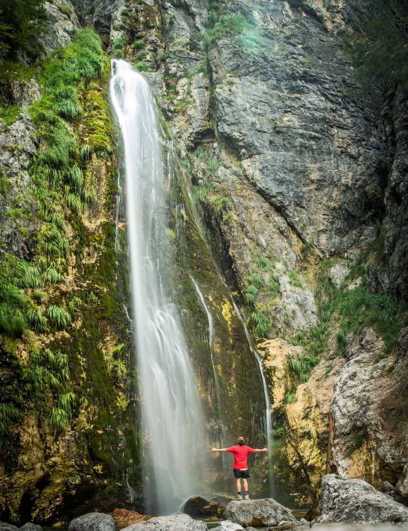
The Balkan Peaks Trail takes you through a remote and unspoilt mountain region in the Western Balkans. The trail comprises 192 kilometres of marked hiking trails through picturesque villages and remote valleys. The route winds through the high alpine mountains and crosses several mountain landscapes that offer a variety of breathtaking views. Green valleys, crystal-clear mountain lakes, waterfalls and rivers - there is plenty to discover. In this hidden gem, there are many picturesque mountain villages where time seems to have stood still. Just 20 years ago, the region was practically inaccessible to visitors, making it an authentic cultural experience today. With differences in altitude of 1000 metres per day, the hike is certainly not to be underestimated; you are on the move for 5 to 8 hours a day. For real mountain enthusiasts!
Which peaks will I encounter?
Albania
Kosovo
Montenegro
The peaks of the Balkans are a collection of beautiful and spectacular mountains shared by Albania, Kosovo and Montenegro. The Balkan Peaks Trail connects the three countries with a circular hiking route. The entire route is marked, a map of the route can be found below.
The Balkan Trail has several starting points. In Albania you can either start in Theth. You fly to the capital Tirana and take public transport to the starting point. Starting in Theth means that you immediately get to know the national park of the same name. It's similar in Valbona; you enter the Valbona Valley National Park directly. Thanks to flight connections with an international airport in Tirana, these are the most popular starting points. However, there are other options. Podgorica in Montenegro and Pristina in Kosovo also have international airports, but with far fewer connections.
You'll be physically exerting yourself during the day, so you don't want to compromise your sleep. You'll be staying in guesthouses and shepherd's huts. These are often small, cosy accommodations where you have the chance to meet the locals. Most guest houses provide bed linen, blankets and pillows. You will be welcomed with open arms and can enjoy fresh meals made from local produce - salads with cucumber, tomato and onion or stuffed peppers with green beans stewed in milk. And round it all off with a cup of Turkish coffee!
The same applies to the shepherd's huts, although you should expect less comfort here. The facilities are basic, but certainly sufficient for a good night's sleep! Enjoy simple but nutritious stews or grab a slice of crumbly curd cheese. If you're lucky, you can also try a homemade jam.
Are you planning to discover the Balkans via the Peaks of Balkan? That's a great idea! What costs do you need to consider if you are planning this hike on your own? First of all, travelling to the starting point of the trail. For a return flight to Tirana (Albania) you will pay around €200, depending on which country you are coming from. During the hike you will mainly stay in guesthouses; for half board you will pay approx. 25 € per night. You will pay around €8 for dinner. This information has been incorporated into the following example; it gives a good indication of the costs:
